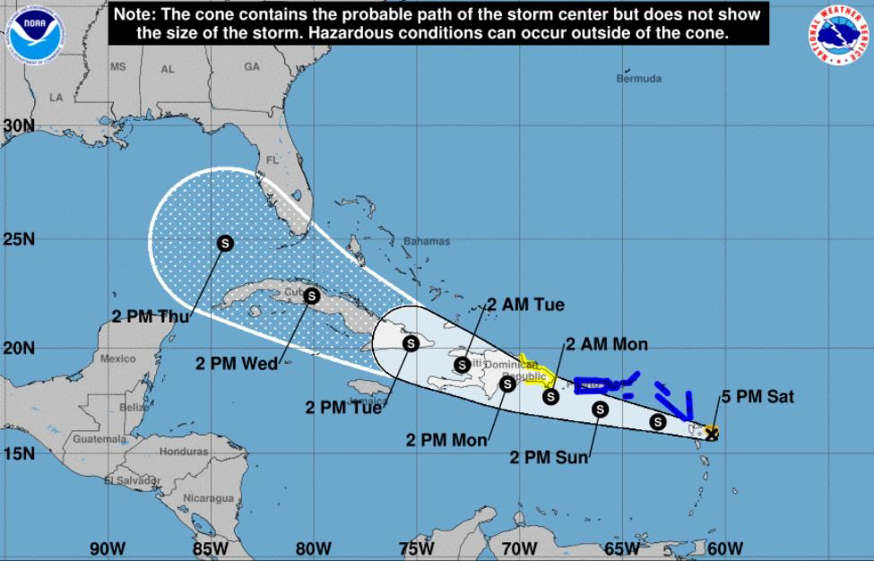
FORT LAUDERDALE, Fla. (Florida Sun Sentinel) – Tropical Storm Grace, which formed early Saturday morning in the Atlantic Ocean, saw its wind speed decrease and had its forecast track shift west, taking Palm Beach and most of Broward out of its path.
The storm still has a long-range forecast that affects Florida by midweek.
Grace became the seventh named storm of the Atlantic hurricane season, and has a similar forecast track as Fred, now a tropical wave , the National Hurricane Center said in its 5 p.m. update.
As of 5 p.m., Grace was centered about 55 miles east-southeast of the eastern Caribbean, moving west at 26 mph with maximum sustained winds of 40 mph, which is 5 mph slower than it was three hours earlier.
A tropical storm warning was issued for the U.S. Virgin Islands, Puerto Rico and British Virgin Islands. Grace could reach the Dominican Republic by Monday, according to forecasters, and is expected to bring heavy rain and flooding.
The storm’s possible paths include the Gulf of Mexico and farther up the northeast coast of the United States. But in the shorter run, it may follow Tropical Storm Fred across the mountains of the northern Caribbean, which could limit its chances of becoming dangerously powerful. The current forecast shows the storm achieving its maximum wind speed of 50 mph as it approaches the Dominican Republic early next week.
The long-range forecast has it parked in the Florida Straits by Thursday as a weak tropical storm with 45 mph sustained winds and 60 mph gusts.
At the moment, the system is small with tropical-storm-force winds extended out 35 miles.
The storm is expected to move west or west-northwest over the next few days. Its center will move over the eastern islands of the Caribbean on Saturday night before moving over the U.S. Virgin Islands and Puerto Rico on Sunday, forecasters said. Tropical Storm Grace is expected to move over the Dominican Republic on Sunday night and then over Haiti on Monday night.
Like Fred, this storm could run the gauntlet of mountainous islands on the northern Caribbean, which could drain a lot of its strength, making it difficult to say how much of a threat it could be to the United States. One model shows the storm reaching hurricane strength in three days, but the National Hurricane Center called that an “extreme outlier.”
“It is way, way, way too soon to speculate about potential impacts to the southeast coast of the United States,” said Jamie Rhome, a meteorologist at the National Hurricane Center. “That said, it’s August. It’s in the middle of hurricane season. So coastal residents anywhere in the Gulf, Florida and the southeastern United States should be paying really close attention to this system as it makes its way in the general proximity of the United States in the next five to seven days.”
Robert Molleda, warning coordination meteorologist for the National Weather Service in Miami, said the atmosphere ahead of the storm doesn’t appear particularly favorable for it to get very strong. And he said the storm’s projected course looked similar to that of Fred, which weakened from a journey across the mountainous islands of the Caribbean. But he said it’s still early, and forecasters will soon have a better sense of the storm’s likely path and strength.
“For right now, it does not pose any significant threat to South Florida at this time,” he said. “But we’re going to be watching it and see how it progresses over the next day or two.”
The storm faces obstacles including dry air and wind shear, crosswinds that can inhibit the formation of a tropical cyclone’s rotating structure, according to AccuWeather, the private forecasting service.
“The tropical rainstorm is embedded within an area of drier air and has some African dust to its north and west which is working to slow development,” said AccuWeather Meteorologist Adam Douty.